Bush Explorers Encyclopaedia
Name:
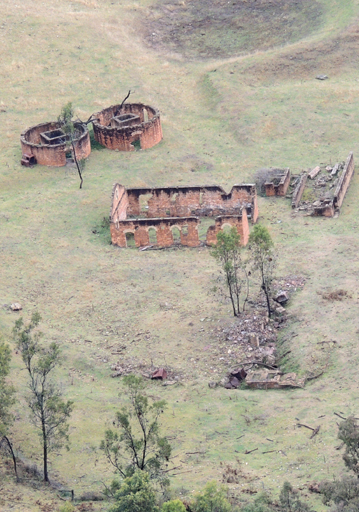
Torbane
Description:
Was a private village, constructed in 1889 for employees working the retort complex that processed kerosene shale transported by various means from the mines in the adjoining eastern valley of Airly. Torbane School opened in October 1899 and closed in September 1920. Torbane in NSW was named after a village of that name in Scotland which came to be associated with the Boghead Deposits discovered in 1844. At the time, the mineral Torbanite became known as Boghead Mineral. Commercial extraction of oil on the shores of the North Sea dates back to 1851, when James Young retorted oil from Torbanite. Ref: Eardley, G H. and Stephens, E M. The Shale Railways of NSW, 1974, p. 99.
Maps:
- Glen Alice
Grid Reference:
- 215 334
Location:
Mugii Murum-ban State Conservation Area
Status:
Threatened
Related Names:
Read More In:
Walks:
- GOS1.01: Blacks Corner
- GOS1.02: Genowlan Mountain
- GOS1.03: South West end of Airly
- GOS1.04: Airly Creek and Winding Pinch Creek
- GOS1.05: East Mount Airly
- GOS7.14: Hartley Vale Mines
Photos: