Bush Explorers Encyclopaedia
Name:
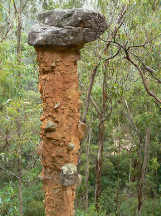
Totem Pole
Description:
Is a loosely consolidated rock column with a protective natural capstone. It islocated 240m upstream of the junction of Houstons Creek and Wolgan River and 45m above the southern bank of the Wolgan River. Measuring 6m in height, it has a circumference at the base of 3.4m and a capstone of 1.5m in width. This 6m high pinnacle was recorded in Joseph Carne's field book, 1907. A captioned photo taken records it as "Earth Pillar, the Pinnacle, Wolgan Valley", c1908. Ref: Department of Primary Industries and State Records. Named as the Totem Pole by Joseph Mack in 1975. Ref: Correspondence from Joseph Mack, 3rd March 2009.
Maps:
- Mount Morgan
Grid Reference:
- 577 200
Location:
Wollemi National Park
Status:
Protected
Related Names:
Walks:
- GOS2.26.1: The Totem Pole
- GOS2.26.2: The Totem Pole
Photos: