Bush Explorers Encyclopaedia
Name:
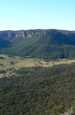
Wolgan Valley *
Description:
Is an enclosed valley that has only one road access via Lidsdale and Wolgan Gap. It was Campbell Mitchell, son of Sir Thomas Mitchell, who was the first to discover kerosene shale deposits in the Wolgan Valley and open up a mine in 1873. Ref: Carne, Joseph. The Kerosene Shale Deposits of New South Wales, 1903, p. 38.
Maps:
- Cullen Bullen and Ben Bullen
Grid Reference:
Location:
Status:
Related Names:
Read More In:
Walks:
- GOS1.07: McLeans Pass and further east
- GOS1.12: Collett Gap and Woolpack Rock
- GOS1.13: Crown Creek and Hughes Defile
- GOS1.17: Poseidon Area
- GOS1.20: Hecates Cauldron
- GOS1.25: South of Hecates Cauldron
- GOS2.01: Mount Harvey and Mount Dawson Pass
- GOS2.02: Mount Dawson and Gindantherie Pinnacle
- GOS2.03: Point Anderson and Canobla Creek
- GOS2.06: The Wolgan - Capertee Divide
- GOS2.07: Petries Gully Circuit
- GOS2.08: A special side canyon in Petries Gully
- GOS2.09: Two of the ridges north of the Newnes Hotel
- GOS2.10: The Pipeline Track
- GOS2.11: Mystery Mountain
- GOS2.12: The Wolgan Valley from Glowworm Tunnel to Newnes
- GOS2.13: Newnes - Wolgan River - Zobels Gully Triangle
- GOS2.14: The Cliffs of Mars
- GOS2.17: Constance Point
- GOS2.18: Penrose Slot and more
- GOS2.19: The Minotaur Lair
- GOS2.20: Penrose Gully South
- GOS2.21: The cliffs of Koopartoo
- GOS2.23: Crossing the Koopartoo Mesa
- GOS2.25: Island Mountain Traverse
- GOS2.26.1: The Totem Pole
- GOS2.26.2: The Totem Pole
- GOS3.01: Donkey Mountain 1
- GOS3.03: Donkey Mountain 3
- GOS3.04: Wolgan Pillars
- GOS3.05: Yerra Yerra Pass, Bubyong Pass and part of Mt Cameron Plateau
- GOS3.08: Cliffs north of the Glowworm Tunnel - Part 1
- GOS3.09: Cliffs north of the Glowworm Tunnel - Part 2
- GOS3.10: Carne Creek Cliffs, Nobles Canyon and the fissures
- GOS3.12: Carne Creek Cliffs Screwdriver pass and the Long Zig Zag Pass
- GOS3.18: Above the Glowworm Tunnel
- GOS3.20: Unnamed tributary of Deanes Creek
- GOS4.11: Bungleboori Creek and the WWII Water Supply Dam
- GOS5.03: Sisyphean Ridge
- GOS5.05: Exploring Cape Horn
- GOS5.12: Wolgan Gap Trig
- GOS5.13: Wolgan Gap cliff line
- GOS5.16: Four Level Cave
- GOS5.19: Neubecks Creek and Alois Creek
- GOS5.20: Alois Spur
- GOS5.24: Lambs and Kangaroo Creeks ridge line
- GOS6.01: The Temples of Doom
- GOS6.02: Last Crusade Point and Holy Grail Ravine
- GOS6.03: Indiana Gorge and Indiana Slot
- GOS6.04: Spanish Steps to the Wolgan Falls
- GOS6.06: Cliff Lines above the Wolgan River
- GOS6.07: Cape Pinnacle
- GOS6.08: Rockflower Ridge and Creek
- GOS6.09: Sunnyside Cliffs and Bushrangers Creek
- GOS6.10: Sunnyside Canyon and Ravines
- GOS6.11: Flat Bottom Creek
- GOS6.12: Donkey View Pass
- GOS6.13: Sunnyside Gully
- GOS6.14: Sunnyside Point and Wolgan Pinnacle
- GOS6.15: Western side of Endorphin Gully
- GOS6.17: Infinity Caves
- GOS6.19: Adrenalin Ledge Traverse
- GOS6.21: Adrenalin and Thom Slots, plus Pleasant View Canyon
- GOS6.23: Pyramid Pass to Zorro Pass
- GOS6.24: Window in the Sky Ravine and Striolata Ravine
- GOS6.27: Carne Creek and Glory Box
- GOS6.32: Gang Gang Playground
- GOS7.11: Wolgan River bends above Wolgan Falls
- GOS7.19: Blacksmith Cave
Photos: