Bush Explorers Encyclopaedia
Name:
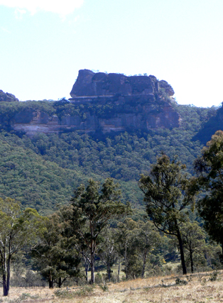
Woolpack Rock *
Description:
Is a rock formation in the mesa 2.2km east of Mount Davidson and Wolgan Trig Station. Named by Surveyor John Byrne Richards and shown on his Survey Plan, 3rd January 1831 as The wool-pack-rock. Ref: Survey Plan B4-691r. In early editions of the Parish of Wolgan, shown as Woolpack Rock. This name and the name Wolgan are the first names recorded by Europeans in the Wolgan Valley. Described by Michael Keats, 4th September 2009, as, " Woolpack Rocks, looking like 4 huge woolbales, batched together."
Maps:
- Ben Bullen
Grid Reference:
- 338 202
Location:
Gardens of Stone National Park
Status:
Protected
Related Names:
Read More In:
Walks:
- GOS1.07: McLeans Pass and further east
- GOS1.12: Collett Gap and Woolpack Rock
- GOS2.02: Mount Dawson and Gindantherie Pinnacle
- GOS5.05: Exploring Cape Horn
- GOS6.10: Sunnyside Canyon and Ravines
- GOS6.14: Sunnyside Point and Wolgan Pinnacle
Photos: